Tropical Storm Fernand forms near Bermuda, no direct threat to Caribbean
The NHC reported that Tropical Storm Fernand, once known as Invest 90L, is tracking north at 15 mph with winds near 40 mph, positioned roughly 295 miles south-southeast of Bermuda.
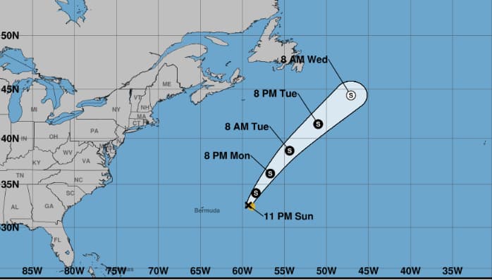
The National Hurricane Center has confirmed the formation of Tropical Storm Fernand, the sixth named storm of the 2025 Atlantic hurricane season. Fernanda is currently located southeast of Bermuda with maximum sustained winds of 40 mph and is currently moving northward. The storm Fernanda is expected to strengthen further over the next couple of days and will potentially reach hurricane strength before weakening on Tuesday, said forecasters.
According to the NHC report, Tropical Storm Fernand which was formerly named Invest 90L is currently located approximately 295 miles south-southeast of Bermuda and it is moving north at 15 mph with sustained wind of 40 mph.
The NHC forecasts Tropical Storm Fernand is expected to move north-northeastward with accelerated speed at 15 mph over the next couple of days which will be followed by a turn to the northeast with 291 mph. The tropical storm Fernand is further forecasted to move past the east of Bermuda and across the open waters of the subtropical North Atlantic.
<blockquote class="twitter-tweet"><p lang="en" dir="ltr">5am Mon 8/25: Tropical Storm <a href="https://twitter.com/hashtag/Fernand?src=hash&ref_src=twsrc%5Etfw">#Fernand</a> will remain out over the open Atlantic. More info: <a href="https://t.co/tW4KeGdBFb">https://t.co/tW4KeGdBFb</a> <a href="https://t.co/rMybWIwOzk">pic.twitter.com/rMybWIwOzk</a></p>— National Hurricane Center (@NHC_Atlantic) <a href="https://twitter.com/NHC_Atlantic/status/1959901778247364818?ref_src=twsrc%5Etfw">August 25, 2025</a></blockquote> <script async src="https://platform.twitter.com/widgets.js" charset="utf-8"></script>
Notably, forecasters monitoring the development predict that the tropical storm Fernand will strengthen over the next 48 hours and become a hurricane on Monday but it is still expected to be weakening on Tuesday.
The forecasters described that the tropical storm Fernand poses no direct threat to land and will move past the sea and traverse the open ocean of subtropical North Atlantic. Additionally, they stated that surf impact will be significantly less than what Storm Erin had brought.
Tropical Storm Invest 99L development in Trinidad and Tobago
Another tropical storm named ‘99L’ which is a well known tropical wave is being monitored by the NHC for development and it is forecasted to pass by north of Trinidad and Tobago on Sunday.
However, Trinidad and Tobago Meteorological Service has issued an adverse weather alert for the region and surrounding waters due to high moisture, light winds and the potential for slow-moving showers and thunderstorms
The forecasters stated that there is a probability that Invest 99L could turn into at least a tropical depression.
<blockquote class="twitter-tweet"><p lang="en" dir="ltr">TROPICS: Tropical Storm Fernand, in the open Atlantic with winds of 45 mph, is about 295 miles east of Bermuda. It is moving to the north/northeast at 13 mph, and will stay far from land. It becomes post-tropical Tuesday night.<br><br>The other feature of interest is Invest 99L, just… <a href="https://t.co/CmQR6ZKAAO">pic.twitter.com/CmQR6ZKAAO</a></p>— James Spann (@spann) <a href="https://twitter.com/spann/status/1959759164609073304?ref_src=twsrc%5Etfw">August 24, 2025</a></blockquote> <script async src="https://platform.twitter.com/widgets.js" charset="utf-8"></script>
Significantly, all forecasted models point towards that there will be some weather activity which will be affecting mainly the western areas of both islands on Sunday with additional scattered activity may occur beyond the specified alert period. The additional activity is expected to happen either in the early morning or early afternoon.
TTMS advised the resident to secure loose outdoors objects, take necessary precautions to reduce the potential impacts, continuous monitoring of the weather and avoid the alerted areas.
Jamaica records a tropical wave
Weather reports indicate that tropical waves east of the island will reach Jamaica on Monday afternoon and evening with potential showers and thunderstorms.
According to the Meteorological Service of Jamaica reports, the showers and thunderstorms are expected to develop in the eastern parishes on Monday morning with cloudy conditions spreading to central and western parishes later in the day.
The Meteorological Services of Jamaica, forecasted afternoon showers and thunderstorms, mainly in the area of western region on Monday, southern parishes on Tuesday and mostly other regions on Wednesday. Further it is reported that storm Fernand located in southeast of Bermuda posed no threat to Jamaica.
Author Profile

Monika Walker is a senior journalist specializing in regional and international politics, offering in-depth analysis on governance, diplomacy, and key global developments. With a degree in International Journalism, she is dedicated to amplifying underrepresented voices through factual reporting. She also covers world news across every genre, providing readers with balanced and timely insights that connect the Caribbean to global conversations.
Latest
- Jamaican Minister Desmond McKenzie pepper-sprayed by police...
-
St. Kitts and Nevis Restaurant Week 2026 kicks off July 16 w... -
Julien Alfred clocks season's best 10.87 to win Budapest 100... -
US and CARICOM sign Biometric Data-Sharing Agreement to stre... -
Guyana to launch full online curriculum through digital scho...