Tropical Storm Erin likely to become 1st major hurricane of 2025, threatening NE Caribbean this weekend
Tropical Storm ERIN is looking much healthier this Thursday morning, and it's likely to become the Atlantic Ocean's first hurricane of the year - Forecaster Josh Morgerman
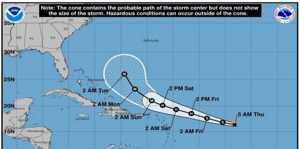
Tropical Storm Erin is expected to potentially become the first major hurricane of the 2025 Atlantic hurricane season, reaching category 3 or higher with winds of at least 115 mph by this Saturday. As of 8:15 am (Eastern Caribbean time), Tropical Storm Erin has entered the monitored area and is expected to strengthen into a hurricane by Friday.
Currently, it is located 904 miles east of the Leeward Islands. Forecasters predict that the warm waters of the southwest Atlantic Ocean could enable Erin to strengthen into a hurricane.
Moving west at 17 mph, forecasters predict that Erin could pass dangerously close late Friday night into Saturday. On its current track, the center of Erin is expected to pass north of the area, but a shift southward could bring it uncomfortably close to the islands.
The Antigua and Barbuda Meteorological Service has placed a Tropical Cyclone Alert in effect while a Tropical Storm Watch may be issued later today or tonight.
Moreover, it is also reported that storm wind chance is up to 45% for Anguilla and parts of the British Virgin Islands while it will lower elsewhere.
With this, the chances of storm-force winds hitting Antigua and Barbuda and the rest of the Northeastern Caribbean have increased by 33%.
<iframe src="https://www.facebook.com/plugins/post.php?href=https%3A%2F%2Fwww.facebook.com%2FAccuWeather%2Fposts%2Fpfbid023tbUeQbUX38U9jai8iTTFpbh3VH95Wnj3jYFNSxrPRXHkGqu4w1yKrRPKgZeLztyl&show_text=true&width=500" width="100%" height="648" style="border:none;overflow:hidden" scrolling="no" frameborder="0" allowfullscreen="true" allow="autoplay; clipboard-write; encrypted-media; picture-in-picture; web-share"></iframe>
The NHC's forecasters expect the fifth named storm of the Atlantic hurricane season to start intensifying by late Wednesday and potentially become a hurricane by late Thursday or Friday.
NHC also advised in their statement that the northern Leeward islands, Virgin Island and Puerto Rico should monitor the progress of Tropical Storm Erin as they are likely to cause life threatening conditions at local beaches.
Meteorologist Orvin Paige stated that “the risk for the Leewards has increased just a little bit but still presents an uncertain scenario in terms of impacts.” He further emphasised that, even though the risk is palpable, it is still too early to know exactly what impact this cyclone will bring to the islands.
Notably, there are no cyclone alerts issued in the northeast Caribbean but it could be changed by tomorrow and the forecasters advise the citizens to continue watching the progress and prepare themselves accordingly.
Author Profile

Monika Walker is a senior journalist specializing in regional and international politics, offering in-depth analysis on governance, diplomacy, and key global developments. With a degree in International Journalism, she is dedicated to amplifying underrepresented voices through factual reporting. She also covers world news across every genre, providing readers with balanced and timely insights that connect the Caribbean to global conversations.
Latest
- One killed, two injured in triple shooting in Belize's Cayo...
-
Operation Iceberg exposes alleged human trafficking network... -
Jamaica: Police say no evidence links Delroy Coke to Shani C... -
St. Kitts and Nevis records lower crime rates in latest mid-... -
MV Golden Carrier to replace Blue Wave Harmony on Trinidad-T...