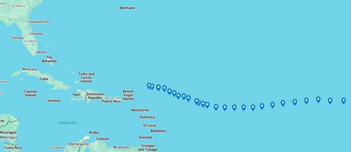
Eastern Caribbean on watch as Hurricane Erin surges to Cat 3 with 120mph winds
Hurricane Erin reached Category 3 strength in the Caribbean early Saturday and is forecast to intensify further throughout the day.

The National Hurricane Center has released its latest advisory confirming that it has intensified into a Category 3 Hurricane having wind speed of 120 mph and gusts of 150 mph. The Center said that it is moving at a speed of 20mph WNW.
The Center also said, “Erin is rapidly intensifying north of the Eastern Caribbean islands.”
<blockquote class="twitter-tweet" data-media-max-width="100%"><p lang="en" dir="ltr"><a href="https://twitter.com/hashtag/Erin?src=hash&ref_src=twsrc%5Etfw">#Erin</a> is rapidly intensifying north of the eastern Caribbean Islands. Here are the Key Messages from the 5 am AST advisory. Visit <a href="https://t.co/tW4KeGdBFb">https://t.co/tW4KeGdBFb</a> for updates. <a href="https://t.co/wZOHiVd02y">pic.twitter.com/wZOHiVd02y</a></p>— National Hurricane Center (@NHC_Atlantic) <a href="https://twitter.com/NHC_Atlantic/status/1956642436630897009?ref_src=twsrc%5Etfw">August 16, 2025</a></blockquote> <script async src="https://platform.twitter.com/widgets.js" charset="utf-8"></script>
Hurricane Erin might have Delco in its crosshairs. What started out as a tropical storm days ago has now exploded into Hurricane Erin, rapidly intensifying into a Category 3 and forecasters warn it could be the most dangerous storm to threaten our region in decades. It’s already creating 50-foot waves out in the Atlantic.
<blockquote class="twitter-tweet"><p lang="en" dir="ltr">The National Hurricane Center has released its latest advisory on Erin. We’ll be closely monitoring this storm and providing updates over the coming days. <a href="https://twitter.com/hashtag/Hurricane?src=hash&ref_src=twsrc%5Etfw">#Hurricane</a> <a href="https://twitter.com/hashtag/Erin?src=hash&ref_src=twsrc%5Etfw">#Erin</a> <a href="https://t.co/DW5kt06Xtc">pic.twitter.com/DW5kt06Xtc</a></p>— Daniel Bonds (@Daniel_Bonds) <a href="https://twitter.com/Daniel_Bonds/status/1956635990971253070?ref_src=twsrc%5Etfw">August 16, 2025</a></blockquote> <script async src="https://platform.twitter.com/widgets.js" charset="utf-8"></script>
Early models are showing multiple possible tracks, but one path has Erin making a hard turn up the East Coast, aiming straight for the Philadelphia area… and you know Delco is right in the impact zone. If that happens, the storm could bring winds over 140 mph, flooding rains, and widespread power outages across our neighbourhoods.
Meteorologists are calling Erin “explosively strengthening” as it churns through warm Atlantic waters, the same kind of conditions that fuelled the last couple catastrophic storms. Some even warn it could grow stronger than Sandy before making landfall. While nothing is set in stone, the next 48 hours will be critical. One thing’s for sure, if Erin comes straight for us, we’re in for one hell of a ride.
Author Profile
Monika Walker is a senior journalist specializing in regional and international politics, offering in-depth analysis on governance, diplomacy, and key global developments. With a degree in International Journalism, she is dedicated to amplifying underrepresented voices through factual reporting. She also covers world news across every genre, providing readers with balanced and timely insights that connect the Caribbean to global conversations.
Latest
- Caribbean Princess cruise passengers denied entry in Bahamas...
-
Three killed in Marchand within 24 hours as Saint Lucia’s ho... -
Belize: Teen charged in fatal shooting at Da Buzz Lounge -
Hantavirus outbreak on MV Hondius claims three lives, ship d... -
St. Kitts and Nevis Citizenship Wins ‘Programme of the Year’...


